


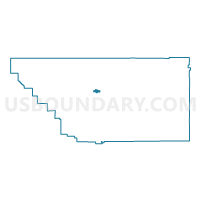
Voting District 30385, Kern County, California
About
Outline

Summary
| Unique Area Identifier | 531603 |
| Name | Voting District 30385 |
| County | Kern County |
| State | California |
| Area (square miles) | 6.31 |
| Land Area (square miles) | 6.25 |
| Water Area (square miles) | 0.06 |
| % of Land Area | 99.00 |
| % of Water Area | 1.00 |
| Latitude of the Internal Point | 35.40549140 |
| Longtitude of the Internal Point | -118.95413890 |
Maps


Graphs
Select a template below for downloading or customizing gragh for Voting District 30385, Kern County, California


Neighbors
Neighoring Voting District (by Name) Neighboring Voting District on the Map
- Voting District 10100, Kern County, CA
- Voting District 10580, Kern County, CA
- Voting District 10590, Kern County, CA
- Voting District 10600, Kern County, CA
- Voting District 30005, Kern County, CA
- Voting District 30020, Kern County, CA
- Voting District 30035, Kern County, CA
- Voting District 30390, Kern County, CA
- Voting District 30395, Kern County, CA
- Voting District 30396, Kern County, CA
- Voting District 30400, Kern County, CA
- Voting District 30405, Kern County, CA
- Voting District 30410, Kern County, CA
- Voting District 30415, Kern County, CA
- Voting District 30615, Kern County, CA
- Voting District 30625, Kern County, CA
- Voting District 30630, Kern County, CA
- Voting District 30635, Kern County, CA
- Voting District 30645, Kern County, CA
- Voting District 30665, Kern County, CA
- Voting District 30670, Kern County, CA
- Voting District 30675, Kern County, CA
- Voting District 30680, Kern County, CA
- Voting District 50145, Kern County, CA
- Voting District 50935, Kern County, CA
Top 10 Neighboring County Subdivision (by Population) Neighboring County Subdivision on the Map
Top 10 Neighboring Place (by Population) Neighboring Place on the Map
Top 10 Neighboring Elementary School District (by Population) Neighboring Elementary School District on the Map
- Bakersfield City Elementary School District, CA (185,976)
- Standard Elementary School District, CA (22,909)
- Beardsley Elementary School District, CA (17,072)
Top 10 Neighboring Secondary School District (by Population) Neighboring Secondary School District on the Map
Top 10 Neighboring State Legislative District Lower Chamber (by Population) Neighboring State Legislative District Lower Chamber on the Map
Top 10 Neighboring State Legislative District Upper Chamber (by Population) Neighboring State Legislative District Upper Chamber on the Map
Top 10 Neighboring 111th Congressional District (by Population) Neighboring 111th Congressional District on the Map
Top 10 Neighboring Census Tract (by Population) Neighboring Census Tract on the Map
- Census Tract 9.10, Kern County, CA (9,904)
- Census Tract 14, Kern County, CA (7,766)
- Census Tract 6, Kern County, CA (6,931)
- Census Tract 9.08, Kern County, CA (5,493)
- Census Tract 8, Kern County, CA (4,925)
- Census Tract 7, Kern County, CA (4,825)
- Census Tract 9.04, Kern County, CA (4,008)
- Census Tract 9.03, Kern County, CA (3,653)
- Census Tract 9.02, Kern County, CA (3,340)
- Census Tract 12.01, Kern County, CA (2,895)